Bam Earthquake Iran
On December 26th ,2003 at approximately 5:37 am an Earthquake measuring 6.6 on the Richter scale struck a Bam, an ancient historic city in Kerman, Iran. The earthquake epicenter was located near Bam however its destruction and aftermath diffused into surrounding provinces in the southeast, such as Baravat.
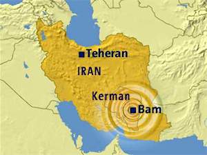
The epicenter of the Bam earthquake has been reported by the United States Geological Survey (USGS) to be located at 29:00N-58.34E, about 185km south east of Kerman .This implies that the epicenter of the earthquake was only a short distance from Bam (29:09N-58.35E) and to the south of the city. (http://www.bhrc.ac.ir/portal/Default.aspx?tabid=919)
Immediate Impacts
11,000 students were killed and 1/5 of the 5,400 local teaching staff were also. This caused a significant problem for the local education system. Eighty-five to ninety percent of buildings and infrastructure in the Bam area were either damaged or destroyed with 70% of houses being completely destroyed, plus 70-90% of Bam's residential areas.This left an estimated 100,000 homeless. Not a single house was standing in Baravat.
(http://earthquake.usgs.gov/earthquakes/eqinthenews/2003/uscvad/)
(http://news.bbc.co.uk/2/hi/middle_east/3579173.stm)
An analysis of the Bam Earthquake impacts and mitigation efforts
No comments:
Post a Comment