Plate Tectonics: Introduction
The world is split up into large plates, and their respective movements are called Plate tectonics.
These boundaries caused the severe earthquakes that Iran endures year after year.
Boundaries can push, pull, or slide against each other. The energy that is released from the boundaries results in earthquakes. The more energy released, the higher the magnitude of the earthquake.
Tectonics in Iran
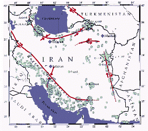
Iran sits in a very complicated tectonic region. To the south of Iran lies the Arabian plate, and to the north lies the rest of the Eurasian plate. Arabia is slowly pushing northward into Eurasia, leaving Iran in the collision zone. In this zone there are several smaller blocks which accommodate the motion. These are so-called microplates. A map of seismicity (seismic activity) in Iran displays an interesting feature. The majority of seismic activity in Iran occurs near its borders. This is because most of Iran sits on one microplate. The size of the circles represents relative intensity of earthquake. ( http://www.ldeo.columbia.edu/~mwest/museum/description.html)
From this map, we can see that many of the earthquakes are concentrated in the southwestern border - but with this map of Iran, many of the cities are near this coast, amplifying the potential for hazards.
Bam Earthquake Tectonics
The Bam earthquake occurred as the result of stresses generated by the motion of the Arabian plate northward against the Eurasian plate at a rate of approximately 3 cm/yr (about one inch per year). This consistent stress as well as release of energy is why Iran consistently has earthquakes. Deformation of the Earth's crust in response to the plate motion takes place in a broad zone that spans the entire width of Iran and extends into Turkmenistan. This again makes earthquakes more dangerous, as much of Iran is effected.
Earthquakes occur as the result of both reverse faulting and strike-slip faulting within the zone of deformation. Preliminary analysis of the pattern of seismic-wave radiation from the December 26 earthquake is consistent with the earthquake having been caused by right-lateral strike-slip motion on a north-south oriented fault. The earthquake occurred in a region within which major north-south, right-lateral, strike-slip faults had been previously mapped, and the epicenter lies near the previously mapped, north-south oriented, Bam fault. (http://earthquake.usgs.gov/earthquakes/eqarchives/poster/2003/20031226.php)

No comments:
Post a Comment